Showing posts with label ACAP. Show all posts

Tuesday, January 6, 2015

Annapurna Circuit - part 1


I have been pretty much motionless since early 2013 after spending 2 months in the hospital and later on, damaging my knee LCL. Good news is, the Conservation Project I was involved with happen to be a good continuity in order to regain my mobility. Living and hiking above 2000m on a daily-base throughout the project was definitively beneficial for my legs and mind to regain some strength. Therefore, I could envision exploring or, at least, get a taste of those appealing mountains surrounding Ghandruk.

I set the achievable goal of completing the Annapurna Circuit trek, and therefore get a better look at those beautiful mountains. This trek is accessible to all as it doesn't require any technical skills and trekkers can find food and/or lodging on trek every hour or two. This circuit remains affordable compare to other treks; only the Annapurna Conservation Area (ACA) Single Entry and Trekkers Information Management System (TIMS) permits (2 x 20 USD) are required for this trek. I managed to pay 100 NRP / night for a room with attached toilet and shower although for food it is another story as prices increase proportionally with altitude.

Annapurna Circuit Map

This is definitely a must do!

From Pokhara one can already enjoy the sight of Annapurna I (8091m) and Machhapuchhare (Fish Tail Peak, 6997m). Although to the north of the massive bulk of the Annapurna is a valley system that leads to Tibet through the villages of Naar and Phu as well as the Mustang region. Unfortunately, the Tourism Bureau would not provide me with a permit for these two areas without a group and guide... 

Tal to Tilicho Lake Map

These two trekking areas have been added to my to do list.
 
I highly suggest to take the local bus to immerse oneself into local's folklore (leaving any security consideration behind). Public bus in Nepal are cheaper than food and pretty entertaining. So after my share of cultural immersion between Pokhara and Besisahar, I started my trek from Ngadi (about 1h bus ride north from Besisahar) without much
expectations and with limited time.

After overcoming the choc of the impressive dam and adjacent road (by and for the Chinese) in the middle of this semi wilderness, I quickly fund myself hiking throughout luxurious vegetation, terraces and villages.

The trail follows the east bank of the Marsyangdi Khola (river) from this point.

Colorful & welcoming Chamche's Guesthouse
While engaging into this journey, one can indulge unique fauna and flora but also witness the day-to-day life-style of the communities occupying the region.

Little adorable friends in Ghermu


Passing by a school between Germu to Tal; 
these kids will do anything do get something out of you! :)

What I find the most interesting is the never ending variety of landscapes. From luxurious forest to arid tundra, through hanging bridges and well-maintained trails, by Hindu Temples
and Buddhist Stupas and prayer wheels....

One of the many suspension bridges...

I believe this one is color blind!

Shepherd at work ;)

Prayer wheels

While appreciating every moment of my journey, I could however capture some environmental threats and/or consequences of this Eco-touristic practice in the region. An important portion of the forest cover is no more due to, what looks like, forest fire and intense logging I believe for the construction of hotel/housing accommodations, and fuel wood for cooking and heating.


Making of wooden boards


Eco-friendly transportation of wooden boards – just kidding ;)

And again, the journey continues with more breathtaking views and surprising findings. In Bhratang trekkers can satisfy their sweet craving with apple pie or fresh apples as Gala and Red delicious where introduced about 50 yrs ago. I also learned from the owner that the current orchards were about to be replaced by a new variety from Holland in order to increase both apple size and productivity. 

Fascinating!
 

Cross-generational exchanges
 
Time to get up in Chame for another great hiking day!

Past Bhratang the trail climbs to Timang and then continues through a section of gorgeous pine and fir forest. Further up, Lower and Upper Pisang (3310 m) are found on both banks of the Marsyangdi Khola in a much more arid environment.


Lower & Upper Pisang from the Pisang Peak Base Camp (4000m)
 
From Pisang it is definitely worth the effort of hiking what they call the high route (north of the Marsyangdi Khola). The mountain views on the on the upper trail via Ghyaru and Ngawal (3660m) are breathtaking and this effort also pays in terms of acclimatisation.
 
To provide kids with coloring crayons rather than sweets or money is, in my opinion, a good idea.
 
Prayer Wheels


Simply magical!


Sunday, November 16, 2014

Annapurna Sanctuary Trek

Don't miss the sign to the Annapurna Base Camp

So five motivated volunteers and myself decided to head to the Annapurna Base Camp (ABC: 4130 m) for a bit of exploration. We left Ghandruk Thursday (Oct. 23) after breakfast with the objective to reach the ABC and return by Sunday.

Five motivated volunteers, myself & the sunrise over the ABC

It took us 4h to reach Chhomrong (2170 m) from our Ghandruk Guest House (2100 m). After traversing the old Ghandruk, an endless stone staircase surrounded by rice and millet paddies took us first all the way down to the Kimrong Khola (river) where a suspension bridge allowed us to reach the opposite side.

Old Ghandruk

Suspension Bridge over the Kimrong Khola

Naturally, what goes down generally goes up again! We then climbed another staircase up to Kimrong (1800 m), Taulung (2180 m) and Chhomrong. After lunch, we made it to Bamboo (2310 m) in 3.5h. Once more, the trail drops down a set of stone steps to the Chhomrong Khola, and then climbs to Sinuwa and on through rhododendron forests although not in flowers at the time, to Kuldi (2470 m) and finally to Bamboo (2310 m) where we spent the night.

Beautiful scenery from Sinuwa looking at Ghandruk
 
Lucky we were to see some Hanuman Langur throughout the luxurious forest
Friday morning, we hiked from Bamboo (2310 m) to Deurali (3230 m) in 2 1/4h passing through Doban (2540 m) and Himalaya (2840 m).

Sure enough, no one ate meat....

Although there were no sight of snow, we passed several avalanche chutes on the way. After a quick bite, and another hour of hiking we reached the Machhapuchhare Base Camp (3700 m) just before the clouds. This mountain is sacred and therefore it is not permitted to climb it.


Machhapuchhare Base Camp 3700 m

We set the alarm clock for 4 am on the following day in order to witness the sunrise illuminating the magnificent amphitheatre of rock and ice surrounding the South Annapurna Base Camp (ABC 4130 m). It took us about an hour to reach the moraine past the ABC.

Temperatures were low and the sight of snow made feel at home for a moment ;)
 
Approaching ABC before sunrise

Sunrise on the Annapurna Base Camp

Once the day took over the sunrise, we headed back to our MBC Hotel ate breakfast and started our descent to Ghandruk. We took 3h to reach Bamboo and 1h to reach Chhomrong where we spent the night. Sunday morning we hiked the last 3 1/4h to Ghandruk early enough to be on time for our 11h lunch at our Guest House.

 
This (minus the crowds), I like!

Sunday, November 2, 2014

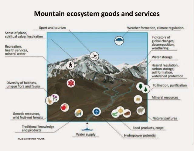
Mountain Ecosystem Goods and Services

When one talks about Goods and Services, everyone understand. Although, when I speak about Ecosystem Goods and Services, a big question mark generally appears in my interlocutor’s face.
 
In short, the term ecosystem refers to the combined physical and biological components of an environment. These organisms form complex sets of relationships and function as a unit as they interact with their physical environment (WHO).
 
Ecosystem Goods and Services are the benefits people obtain from ecosystems, often for free. These include provisioning services such as food and water; regulating services such as flood, weather and disease control; cultural services (non-material benefits) such as spiritual, recreational, and cultural benefits; and supporting services such as nutrient cycling that maintain the conditions for life on Earth. 

These Goods and Services are essential for human well-being and survival. Therefore, when we impact our ecosystems, we consequently impact our well-being.
 
The Millinium Assessment provides a Conceptual Framework of how human well being and health is impacted by changes in ecosystems, at local, regional, and global scales.


The demand for ecosystem services is now so great that trade-offs among services have become the rule. A country can increase food supply by converting a forest to agriculture, for example, but in so doing it decreases the supply of services that may be of equal or greater importance, such as clean water, timber, ecotourism destinations, or flood regulation and drought control.
 
The problem posed by the growing demand for ecosystem services is compounded by increasingly serious degradation in the capability of ecosystems to provide these service. This is particularly true when dealing with mountain environments.
 
http://www.slideshare.net/CIFOR/mapping-vulnerability-and-resilience-for-ecosystembased- approaches-to-adaptation


This is also why I was really interested in learning more about the Nursery Project as Ghandruk is located in a mountain region. Mountain regions are characterized by sensitive ecosystems, enhanced occurrences of extreme weather events, and natural catastrophes such as land slides and floodings or such as the recent avalanche at the Thorung La pass.

View from our guest house 2100 m overlooking from left to right at: Annapurna South 7219 m, Annapurna I 8091 m, hidden behind the mountains Annapurna Base Camp 4130 m, Mardi Himal 5587 m behind the clouds and      Machhapuchre (Fish Tail) 6993m.

This project addresses tree obvious objectives directly linked to the management of difficult environment such as mountain and alpine ecosystems. The first objective being to ensure timber for construction, fuel for cooking and forge plants for buffalo and oxen. Insuring the availability of such plants and schrubs helps reducing soil erosion due to a combination of intense grazing and important precipitations during monsoon’s seasons. Finally, the third objective aims at maintaining and improving the Biodiversity through the growing of rare and endangered species according to IUCN red list.

Sadly, the greenhouse build for the purpose of maintaining Biodiversity through critically endangered tree and schrub species planting was destroyed during last monsoon's season (July & August 2014).
 
Seasonal needs for goods and services are directly linked to tourism

Ever wondered how Tea Houses and Hotels can provide food at such altitudes as the 4130 m of the ABC

Often regarded as hostile and economically nonviable regions, mountains have attracted major economic investments for tourism. We can simply look at the Canadian Rockies or the French Alps to predict the issues places like the Annapurna Conservation Area might be facing in the near-future. The projected amplitude and rate of climatic change in coming decades is likely to lead to significant perturbations of natural systems as well as the social and economic structure of mountain societies, particularly where these are marginal. 

Because in many instances mountains and uplands are regions of conflicting interests between economic development and environmental conservation, shifts in climatic patterns probably will exacerbate the potential for conflict. Sadly, this story seems to repeat itself over and over again around the world.
 
The daily life of Ghandruk communities is closely linked to seasonal cycles both in terms of agriculture and tourism industry which in turn, is under the influence of weather's whims.
 
As a major ecosystem representing the complex and interrelated ecology of our planet, mountain environments are essential to the survival of the global ecosystem. 

Mountain ecosystems are, however, rapidly changing. They are susceptible to accelerated soil erosion,landslides and rapid loss of habitat and genetic diversity. On the human side, there is widespread poverty among mountain inhabitants and loss of indigenous knowledge. As a result, most global mountain areas are experiencing environmental degradation. Hence, the proper management of mountain resources and socio-economic development of the people
deserves immediate action.
 
I certainly hope that the Annapurna Conservation Area Project (ACAP) will continue to work closely with the communities to reduce the degradation of this beautiful place.


With the support of ACAP, solar panels and small hydroelectric plants provide Ghandruk with energy

Thursday, October 9, 2014

Ghandruk

Monday Oct 06, 2014

Namaste Ghandruk!

View from ours bedrooms

On the previous day we hiked under the scorching sun from Kilu (1400 m) to our Ghandruk pahhunahghar Guesthouse (2100 m).

Map found at the Ghandruk Museum

Today, we hike 500 m of elevation to install some cameras for wildlife data collection to determine what species are currently surviving within close proximity to agricultural activities and human encroachment through natural resources collection and also help determine what species are common within the area. We also need to download recorded data and recharge the batteries now and then.


Ours Conservation Project Supervisor and Ornithologist installing a camera

The most exciting part of the day was to be able to observe a young Common Leopard that was rescued after being abandoned by his mother. The animal was relocated in order to reassure the inhabitants and receive necessary care.

Jack and Sacha

The footage captured by the cameras show diverse species among which we fund the Himalayan black bear (Himali kalo bhalu) which also need to be relocated due to potentials conflicts with human and livestock.

At diner time, we celebrated one volunteer's birthday at the German bakery (I guess it is named that way because it sells apple pies, croissants... but it is in fact owned by a Nepalese local). Ironically, the guy we celebrated is "québécois"!


Annapurna south
Macchapucchre


Tuesday Oct 07, 2014

Projects Abroad helps ACAP by providing updated data on various species of mammals, birds, amphibians...

In the morning, we started our bird identification training to be able to help conduct an inventory from collecting data at numerous fixed point bird hides within 5 km radius of Ghandruk. These data help gain knowledge of what species are present in the Ghandruk area and for further work to study migratory patterns.

In the afternoon, we went to a bird observation location of the Himalayan swiflet and Nepal house martin. I was not able to capture any of these fast flying birds on my camera.

On route to the bird observation location

We also contribute to seed dispersal ;)

Tuesday, October 7, 2014

Pokhara to Ghandruk

Saturday Oct. 4th 2014

Time to leave Kathmandu jahnu (to go) to Pokhara. An early 6h30 am start + 7h bus ride later we arrived in Pokhara. 

As soon as the bus started climbing the hills surrounding the city, nature's green and endless terracing replaced the densely populated and extremely polluted Kathmandu.


Bus stop


One of the many suspension bridges on the road

Once more, very little time to explore this city as we arrived pretty late and needed to get organized for yet, another early start the next day for our final destination: Ghandruk.


Pokhara lake

Sunday Oct 5th 2014

Around  7 am we trade the comfort of the Middlepath Hotel in Pokhara for a Jeep ride taking us closer to our destination. About 40 km separates Pokhara (820 m) from a location named Birethanti (1025 m).

This is a well travelled and colorful road. A mix of both locals, tourists buses and Jeeps play a cacophony of klaxons and game of who is passing who... pretty interesting...

Trail from Birethanti to Kilu


Trail from Birethanti to Kilu


Birethanti is also the checking point for the Annapurna Conservation Area (ACAP) permits required to use the trail up to Ghandruk.

From Birethanti (1025 m) our chaffeur drive us another 8-10 km "off road" to the village of Kilu (1400 m). 

Village of Kilu


At this point, our bhariyah (porters) meet with us to load themselves with our bags. I do know the feeling of carrying a 20-30 kg backpack as I have done it myself and therefore, I can only admire their strength when observing these little boys/men and girls hiking up under such loads waring not much than flip-flops...

 
Young female bhariyah (porter) & local woman


Other porters...


Some photos on route to Ghandruk... simply sundar (beautiful)!


Also on the trail, one of the swing built for the Dashain Festival...


We were warmly welcome late afternoon in our Ghandruk  Pahhunahghar Guesthouse (2100 m) with our well deserved camenah (lunch)...

NTNC - ACAP

The girls and myself at the entrance of Ghandruk